telegraph cove
Note. What we refer to on this page as Telegraph Cove, is on the traditional, stolen, unceded, overlapping and/or shared territory land of the Kwakwaka’wakw A̱wi’nagwis First Nations.
We arrived at Telegraph Cove on May 15th 2024 at 1500, after leaving Port Neville at 0600. We had wind up until Growler Cove, but had to motor the rest. The current was with us and gave us an additional 2 knots of propulsion. Having current with you makes for very efficient motoring.
We could see boats around us on AIS, we sailed until we couldn't so we were a bit slower than everyone else, all points appeared to converge on Port McNeill. We knew that our speed would not grant us passage all the way there, but we knew we could make it to Telegraph Cove before the current turned against us. We had planned on anchoring in either Port Harvey or Boughey Bay, to weather out a 30-40 knot gale forecast for the following day, but because we arrived at the entrance to Havannah Channel early (it was 0930), we decided to push on. The current turned to flood at around 1600 that day.
Before we made the decision to go to Telegraph Cove, we called them up to ask if there was room. It's not advisable to just show up without a reservation because the port is small, designed for 10-20 foot speedboats or personal fishing boats. They have very limited moorage for boats our size, therefore first calling is essential to make sure that those spaces are unnoccupied. Space between the docks is very, very tight.
As we motored, we could see a large fog bank forming ahead-great! We piled on layers to stay warm, but the fog dissipated a few minutes after we entered it. The seas were calm and flat then, making for excellent motoring conditions, which means that the strait was full of transiting motor boats. Most boats travelled on the Vancouver Island side of the strait to take advantage of better current, but because we'd been sailing we were on the other shore, it didn't affect us too much though, besides, we had time to get where we wanted to go.
When nearing Telegraph Cove, we saw many large houses on the shore near the entrance, all of them appeared to be under construction. Looking with a set of binoculars, the houses were all pristine, unnocupied, bearing no signs of humans living there full time. We think that these are all vacation homes, AirBnb's... who knows what. This is sad to see. B.C. has become a playground for the rich and for temporary visitors.
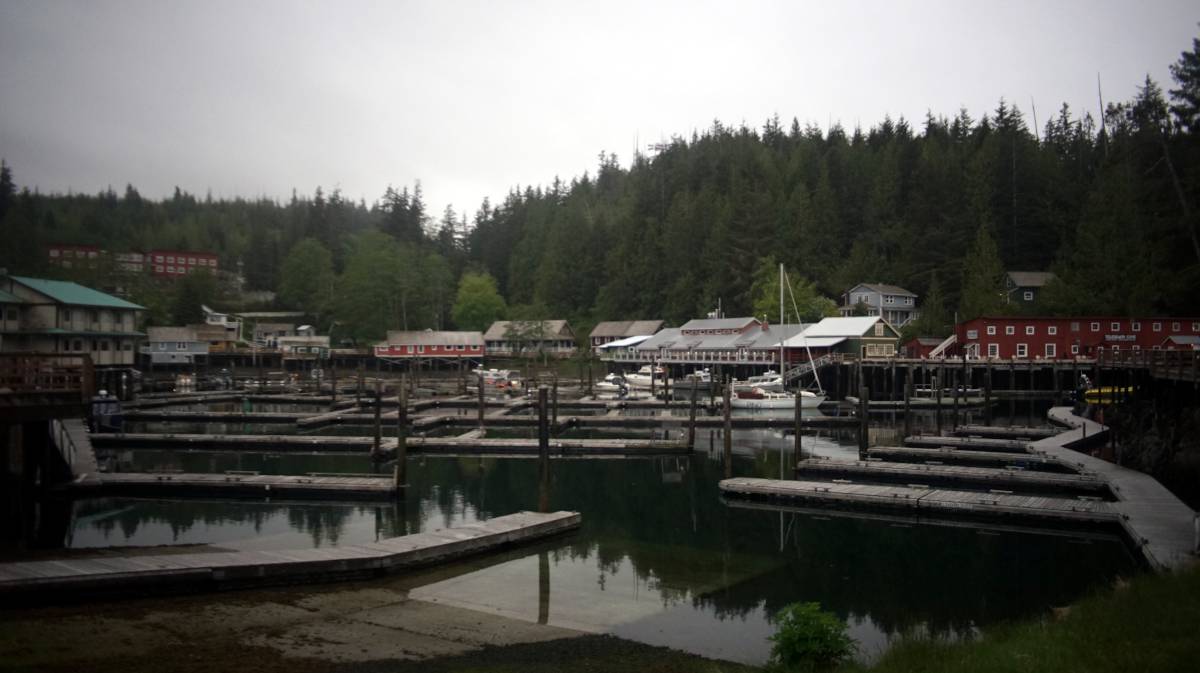
Telegraph Cove hosts two marinas: The Telegraph Cove Resort, and the Telegraph Cove Marina and RV park(where we moored). The Marina and RV park facilities were devoid of boats, we were the only boat occupying the docks (a 40 foot motor boat came in the next day, moored deeper into the marina on the only other appropriately-sized dock, although manoeuvering in there appeared difficult). There is space in the marina for maybe three 10 m (30 ft) boats. They moored us near the entrance, the dock was very near from the 60 m wide entrance channel. Maneuvering in this space with a big boat would be impossible. We had to drive around a piling standing in the middle of the dock area to get to our spot, the piling wasn't supporting anything, a boat entering at night would have rammed into it. Our guess is that there used to be a finger there, but they removed it to create more room for side-tying, or maybe the dock fell apart... hard to say. We found our spot on the dock, just in time too, because the rain started. The cove is very protected from weather, but being at the mouth of the entrance, you do get wakes from passing motor boats, especially those coming in and out of Telegraph Cove.
We called the marina owners to tell them we had arrived. "Tyler will meet you there, just keep an eye out for a camo ATV," Stephanie said. Surely enough, Tyler came to meet up at their office in a camo-covered ATV. His labrador was sitting in the back, king of the backseat. In the shoulder season, they only come to the office when someone comes in. Tyler listed a few of his favorite places in SE Alaska, all fishing-related, we didn't have the heart to tell him that we don't catch or eat fish.
Telegraph Cove is populated with older timber buildings, the cove is bordered by an elevated wooden walkway hosting a few shops. The cove was named in 1911 when a telegraph station was built there. Like many other ports in B.C, it also had a logging camp, a cannery and a sawmill, today, it's a tourist hub. Prince of Whales whalewatching tours operate out of here, as do sports fishermen.
Our next stop, was Port McNeill.