yuculta and dent rapids
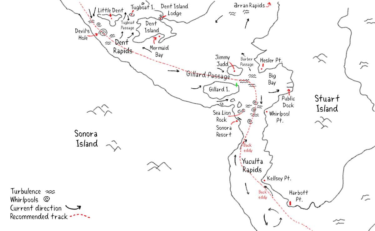
On May 12th at 0500, we left Frances Bay for the Yuculta(pronounced uke-la-taws) and Dent rapids, with plans to traverse all 3 in one go. If the goal is to get there in a timely way with a slow boat, one must find an anchorage that is near the rapids... but there aren't many choices. The closest anchorage is Florence Cove in Hole in the Wall, but it can get quite gusty in there, wind depending, we chose to anchor in Frances Bay, not because we thought it was ideal, but because it was the second closest that offered a bit more protection.
The series of passes from the Yucultas(Yucultas, Gillard Passage and Dent), spans close to 5 NM. For reference, most rapids on this coast are under 0.5 NM. The difficulty in traversing these rapids is because of the distance that must be covered in a short period of time, and that each turn at different times (on an ebb, Dent turns before Gillard). These rapids run fast at peak flood, or ebb. Remember that in this area, the ebb flows north, and the flood flows south.
For both the Yucultas and Dent, the reference station for current in the CHS Tables and/or in Ports and Passes is Gillard Passage. Dent turns to flood 15 minutes, and to ebb 25 minutes before Gillard. During big tidal exchanges, whirlpools, overfalls and boils can appear and endanger passing boats. Yuculta Rapids turn to flood 25 minutes, and to ebb 5 minutes after Gillard.
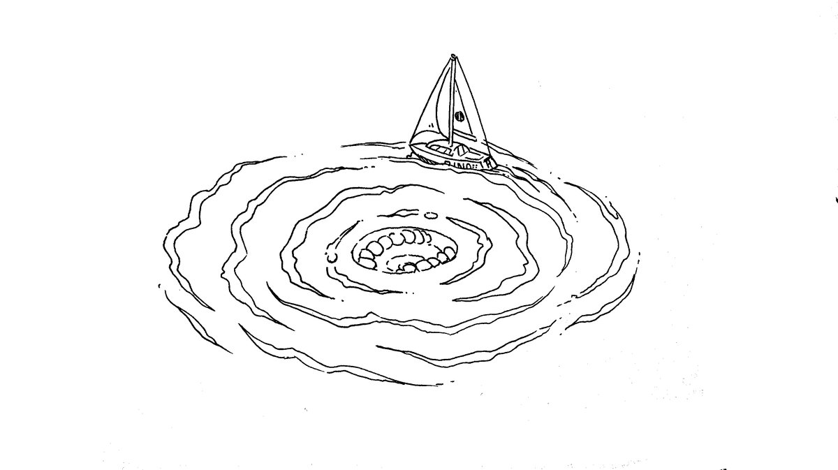
The most notorious obstacle marked up as Devil's Hole on nautical charts, a good name for a fearsome whirlpool that forms just south of Dent on a growing flood. Devil's Hole doesn't form on the ebb, because of how the water is deflected as it travels, but it doesn't make the transit safe at anything but slack(if the traveling is not happening on a neap tide).
- Yucultas to Gillard Passage: 2.1 NM
- Gillard Passage: 0.3 NM
- Gillard Passage to Dent: 2.2 NM
Tactics
Because Pino doesn't motor fast, we like to cross dangerous rapids on neap tides, when the tidal exchange isn't as large, which reduces the strength of the current. Rapids on neap tides aren't nearly as violent, and are much safer to transit. We passed all 3 in one day following the advice listed below.
Ports and Passes tactic: When northbound, arrive at Yuculta Rapids 30 minutes before slack at Gillard Passage. You will have to stem the last of the flood in Yuculta Rapids(and maybe even Gillard Passage), but you should arrive at Dent Rapids when it is nearly slack. The beginning of the ebb will carry you through.
Notes. Not sure what kind of speed Ports and Passes assumes a boat can do, but 30 minutes seems short. It it possible this advice is geared at motored vessels.
Canadian Yachting tactic (By William Kelly): When northbound, slower vessels arriving at the end of a flood can take advantage of a back eddy along the Stuart Island shore up to Kellsey Pt. From there, if conditions are safe, cross to the Sonora Island side of the channel (where the north-going ebb current begins early) and continue to Gillard Passage. We usually like to be in Gillard Pass at the onset of the ebb, but if you find yourself battling a lot of flood current, an alternate route north is to proceed across the mouth of Big Bay and navigate east of the 15.8-metre sounding in Barber Passage, which runs slightly slower than Gillard Passage. Proceeding north from Jimmy Judd Island, arrive with Little Dent Island to starboard and the ebb under way. On a strong flood, Devil's Hole, a turbulent and aerated setion of water south of little Dent Island, can be a frightening spot, but on an ebb the stream is much more consistent because there is nothing to deflect the flowing water. If you find yourself riding a faster ebb than you have planned, stay in the middle of the pass to avoid the set to Tugboat Passage with its dangerous rocks. Once you are clear of Dent Rapids, that is, west of Little Dent, steer north of the shoal patch marked at 6.4 metres depth about a half-mile northwest of the QR light on Little Dent. There can be lots of turbulence here on an ebb.
Notes. We stuck to the regular passes for our transit, we didn't stray so we can't vouch for the Barber Passage detour, but it is wider so it's very likely a good alternate.
Dreamspeaker Series tactic: If you are heading N, approach the Yucultas off Kellsey Pt. on the Stuart Island shoreline an hour prior to the turn to the ebb, cross over, take advantage of the northerly current that prevails along the Sonora Island shore and transit Gillard Passage. It's approximately 5 NM from Kellsey Pt to the Turbulent-free waters in Cordero Channel N of little Dent Island. A sailboat at 6 knots should be able to transit Dent Rapids before the ebb has had time to build to full force.
Notes. Our boat doesn't motor at 6 knots, but we still managed to get good timing by arriving a bit less than 1 hour in advance.
Taking each rapid separately. A slow northbound boat that cannot, or doesn't want, to transit all 3 passes at once, say they cannot time the passing of these rapids with a neap tide, ought to aim for near slack at the Yucultas, transit through, and then spend the night at a dock in Big Bay. The community dock appears cheap and there is a lot of dock space. On the next ebb, near slack, transit Gillard Pass and head for Mermaid Bay to anchor to wait for an ebb slack at Dents before crossing (there is also the more expensive docks tucked just northeast of Dent Island, like Dent Island Resort, and Fisherman's Landing, but they charge something like 4$/foot for an overnight stay).
We had been dreading this passage for a while, but the constant gale warnings in Johnstone Strait forced our hand. We could bypass some of the bad weather by using the back channels, but of course this too comes with some level of danger. Both Johnstone Strait and the back channels are tricky, it is not surprising how some boats never go farther north than Desolation Sound. In all, with careful planning, transiting rapids isn't dangerous, but choosing this path means having to motor. We transited through the 3 rapids with zero issues. After making it past Dent, we made coffee and sipped it to warm our bodies, drinking coffee prior to making a possibly troublesome transit is always a bad idea, it makes us too jittery. Coffee after the difficult bit is over is our prize.
We haven't documented southbound transits yet because we haven't done it.
After the rapids, we went to dock at Shoal Bay.